In my last post I discussed that Cornelis van Roijen was on board the ship Middelwoud when she embarked on her maiden voyage from Wielingen to Batavia, via the Cape of Good Hope, on 14 October 1713.
At the time of writing, I have not had success in locating the ship’s log recording daily events and weather for Middelwoud. I will discuss the specifics where I located data, but otherwise more broadly what we would have expected for the voyage in 1713–1714.
Mustering at Wielengen

Fig. 1: ‘Nieuwe Pascaert Beuattende in sich de Kust van Vlaenderen vande Wielingen tot de Hoofden’(New chart showing the coast of Flanders fromWielingen to Hoofden (the Heads)) (Johannis van Keule, ca1700). Wielengen has been circled in blue on the left of the map.
Wielengen (or De Wielengen) was not a town, but a location just off the Dutch coast near Vlissengen. It is a sea channel near the mouth of an estuary that creates fairly sheltered anchorage protecting against the swells in the open sea. Ships from the VOC chamber of Zeeland were mustered at this location. They would often await the arrival of other ships allowing them to sail in convoy, wait for orders, pilots, and take on provisions. The additional benefit was that the water was deep enough to allow large ships and fleets to anchor.
The captain
The captain (schipper) of Middelwoud was Jan Akkerman of Oosterhout. The wage book indicates that he was paid 80 guilders per month, commensurate with his specialised skill and seniority. He was married to Sara Buijs.[1]
Each ship would have a captain, and the fleet an admiral (commandeur).
There was a division onboard between the duties of the captain and the commercial interests of the Company. The captain was responsible for the practical matters of sailing such as navigation, safety and discipline. On Middelwoud the commercial interests were managed by the onderkoopman (junior merchant) Alexander Faber of Middelburg.[2] Disputes were not uncommon when the priorities of the captain, such as considering the weather could clash with the commercial, such as forcing waits for cargo. Often the commercial interests were managed by an opperkoopman who is more senior, so on Middelwoud Alexander Faber being junior made him subordinate to the captain which would have simplified seniority.
Cornelis as adelborst
With Cornelis holding the rank of adelborst (midshipman) he would have been a trainee, learning skills such as navigation and command. For an adelborst the career path could progress to stuurman (mate) and possibly eventually culminate in captaining a ship. As a trainee Cornelis would have been expected to be able to perform duties such as handling sails and rigging, anchoring, basic navigation (such as competent use of a compass and celestial knowledge), be literate in Dutch and able to do arithmetic. Over time he would learn to handle all aspects of sailing, including discipline on board, record-keeping, managing the guns, among other skills.
Crew and soldiers
The crew of Middelwoud for the first leg to the Cape of Good Hope numbered 123 with a further 43 soldiers on board.[3] The Grootboek for Middelwoud shows the men on board as coming from a number of different countries. Many of the 43 soldiers were from German-speaking countries, with the crew being of Dutch, Scandinavian and of other European origin. Sailors would generally have had experience of life on a ship and known what to expect. This was not as much the case for soldiers.[4]
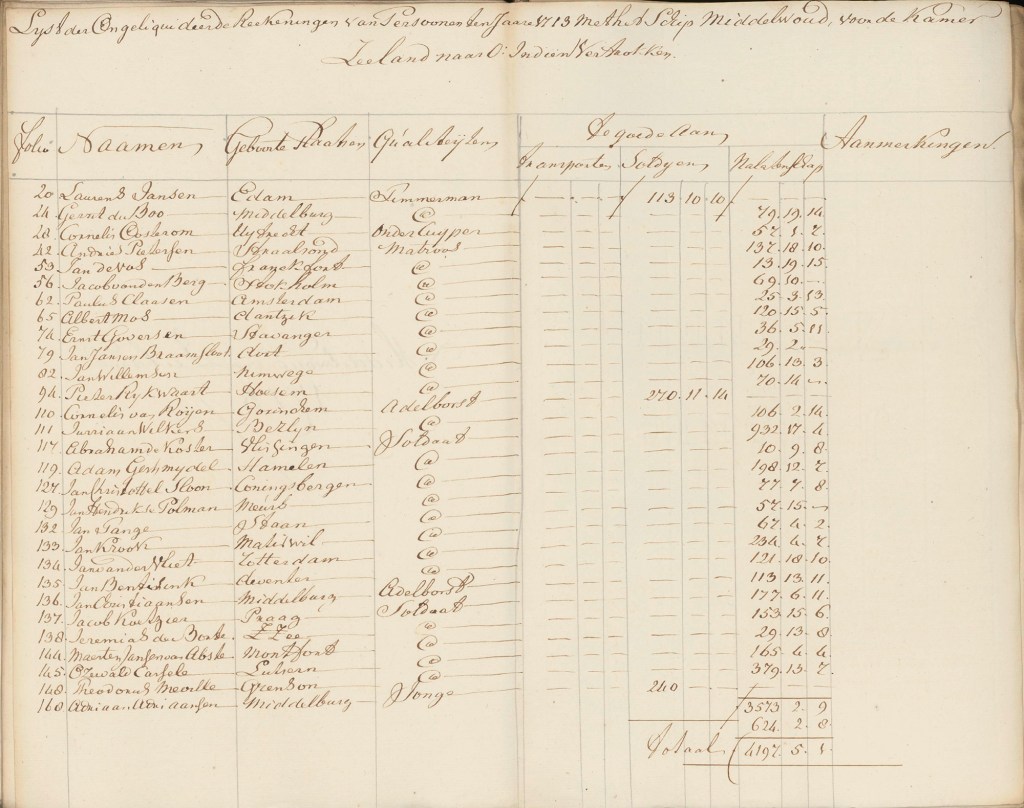
Fig. 2: Page from the wage book showing some of the crew of Middelwoud and the soldiers on board
Route
Around the time Cornelis sailed for the Cape the Maunder Minimum of 1645 to 1715 was not yet at an end. It caused massive cooling, particularly in Northern Europe and was known as the “Little Ice Age”. Coastal flooding destroyed infrastructure, bitter winters choked ports often delaying departures which could extend voyage times and influence utilising favourable winds. Lengthened trips worsened the already enormous problem of scurvy onboard ships. With the atmospheric circulation being affected violent winds and storms were experienced, although these could equally have a beneficial effect on voyage times. The unpredictable weather would have added to apprehension around the very real possibility of being shipwrecked, and the severity of storms experienced.North Atlantic storms are scary enough today with modern ships, so we can only imagine in a wooden ship dependent on sails and rigging.
Middelwoud sailed as part of the kermisvloot (named for a fair in Amsterdam that took place in September) which set out in autumn. Ships would usually follow a mapped-out route as closely as possible, unless extraordinary conditions deemed it necessary to reroute.
Fleets would begin the journey by sailing down the English Channel. By October south-westerly autumn gales could present a challenge, along with an increased risk of fog and rain which could affect visibility. High winds could cause large swells, so care had to be taken near the coast. Depending on the severity of weather there were times when ships would sail westward through the Scottish islands and sail down the western flank of the British Isles.
Once ships had cleared the Channel (usually between three to five days) the next challenge was the Bay of Biscay (six to eight days in autumn). With the sudden change of ocean depth it had a profound effect on the weather caused by the continental shelf falling off sharply. Nearer the coast the continental shelf also causes shallow areas, a hazard for ships.[5] October was a highly variable month which could see brief calm spells, but this could quickly transition to impressive storms, gale-force winds and intense swells. Once this area was cleared ships navigated around the coast of West Africa, and it was possible to stop at Cape Verde to take on fresh water and food supplies.
The next leg was to continue around the West African bulge (three to four weeks) as far south as the winds allowed. When they hit the doldrums (a band north and south of the equator that is part of the Inter Tropical Convergence Zone) it would be necessary to sail sharply southwest toward Brazil (four to six weeks). Some ships also stopped at islands near Brazil for the provisioning.
The doldrums could present an intense challenge. The northern hemisphere winds collide with the southern hemisphere winds. Intense heating near the equator forces moist, warm air upward creating little to no wind at the surface of the sea. Being becalmed, stuck on glassy water possibly for weeks, with listless sails not only delayed the voyage but could have a detrimental effect on the men’s psychology, and put immense pressure on the ship’s supplies. It was possible for storms to form without warning, and everything could go from eerily calm to the ship being battered in a matter of hours.
Once out in the open sea ships made use of the volta do mar, utilising the prevailing westerly winds to speed them to the Cape of Good Hope. It may seem counterintuitive to sail so far west, but fighting winds along the coast of Africa could take longer, and present serious risks.
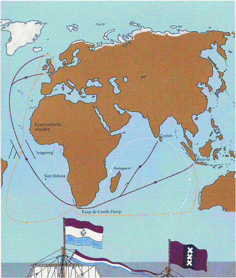
Fig. 3: Map of VOC routes to Batavia (source: R Parthesius, Dutch Ships in Tropical Waters (please see bibliography)
It is interesting to note that the VOC’s Dutch East Indiamen were generally slower than those of other companies, which may be attributed to differences in ship design, and some ports being difficult to access. The VOC focus was on the cargo volume of their ships and not efficiency or speed. This would have added to the cost of the crew and provisions but was likely offset by the profits from larger cargos. Monopolies held by the VOC enabled them to not factor in the competitive commercial advantage of getting goods to market quickly.[6]
Life on board a VOC ship
Much of how life was experienced on board a VOC ship in the Eighteenth-Century depended on the vessel’s captain. Cleanliness was already a difficult business. The decks were scrubbed with salt water but the lower decks often smelled foul, worsened by spillage of human waste from chamber pots, and the manure of animals carried for meat. With fresh water highly prized it was rationed for drinking, not washing. Sailors would have been unlikely to want to bathe with salt water too regularly as it is harsh on the skin and would make their clothing stiff and abrasive. Despite the bilge being pumped out daily, the smell created by the water buildup and lack of ventilation was probably the worst-smelling part of the ship.
Although Middelwoud probably did not have vermin at the time of her launch, they would have quickly appeared at the point of provisioning. With provisions on lower decks, and the buildup of moisture, it would have been difficult to control cockroaches and rats. Livestock would have brought fleas and lice which affected the men too, and what bedding was available was often infested with bed bugs.
As aforementioned scurvy was a problem due to lack of fresh food (and thus vitamin C) on long stretches of the voyage, with the resulting fatigue. Irritability, and a decreasing state of health, would not have helped morale or the psychological strain for those on board. Other communicable disease, such as typhus and dysentery, was a common problem and led to a high mortality rate. What is interesting is that Middelwoud only had two fatalities on her entire journey which is exceptional. With 166 souls on board for the leg to the Cape of Good Hope, and 156 on to Batavia this represents 1.2% and 1.28% respectively. The average on VOC ships of the time could be as high as around 30%.[7]
Sleeping quarters were cramped and privacy was non-existent. Men slept on floorboards or in hammocks. Overall, the noise must have been intense too, both that of those on board and the creaking of the ship, flapping of sails, among other things. It can only be imagined that a ship voyage must have been an assault on all the senses and was not at all glamourous.
With water severely rationed, it was supplemented by beer and diluted wine. Spirits such a gin and brandy were kept on board, but along with lemon juice and vinegar were primarily for medicinal use. Men who had scurvy added considerably to the strain on water supplies due to it creating severe thirst.[8]
The food on board VOC ships was monotonous and before long spoiled with mould and weevils. The diet often comprised cured meat, hardtack, dried fish, peas, beans and rice. Fresh food would only really be available just after taking on provisions, but would not have lasted very long.[9]
A ship is not a democracy. In order to maintain discipline among crews of diverse men, dissent or mutiny was met with brutal reprisal, which included corporal punishment, being confined and even execution. The VOC employed a strict moral code built on their Calvinist ethos, with daily prayers and Sunday worship. What were considered more minor offences such as gambling, drunkenness and blasphemy could incur fines, or loss of rations, but more serious offences such as fighting, violence, and insubordination, would lead to men being flogged or confined. Mutiny and sexual assault were likely to see men hanged or thrown overboard to meet their fate.[10] While it seems severe to us today, ships were already a dangerous place, and a breakdown in discipline presented a very real threat to life and limb. Discipline also served as a preventative measure to reinforce authority and ensure the hierarchy was clearly understood. Despite this bad behaviour was a constant problem and punitive measures were a daily business.[11]
The crew of each ship worked in four-hour shifts which for Cornelis would likely have included ensuring the ship was on course and taking note of issues with rigging or other hazards. His time was also likely consumed by his training, as discussed earlier. When not on shift the men spent time maintaining personal items, the literate ones may have read (primarily scripture, but books were scarce), socialising and personal care.
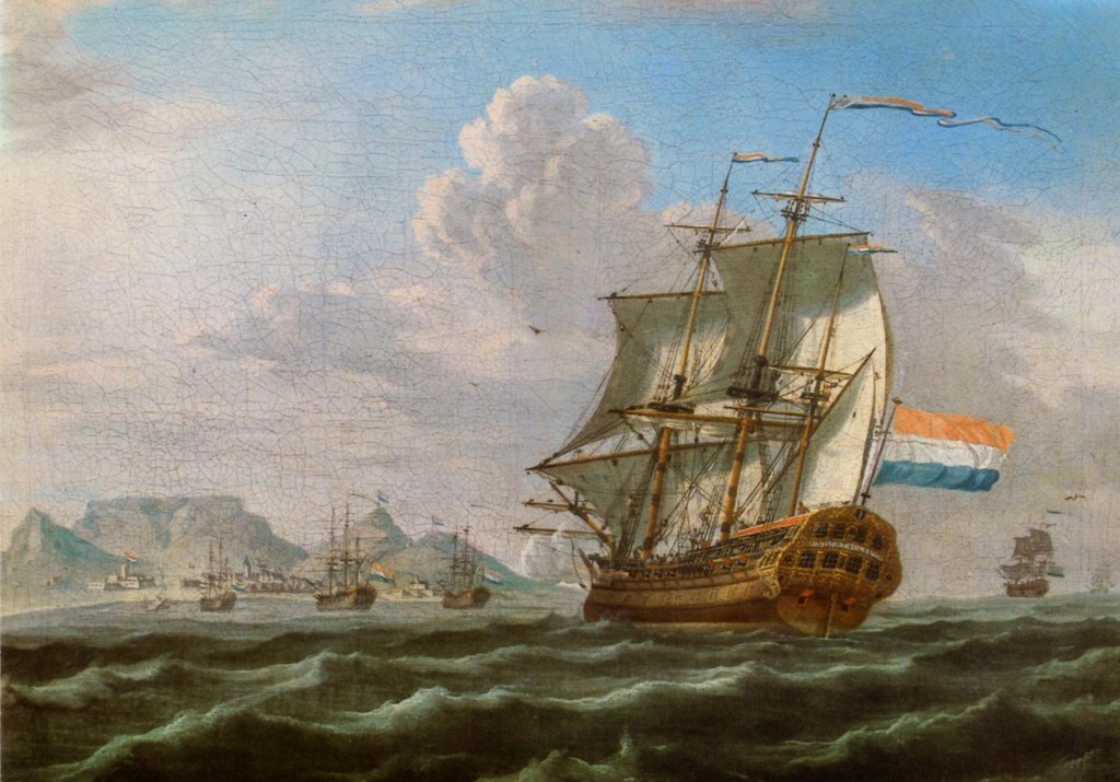
Arrival at the Cape of Good Hope
In the diary entry at the Fort at the Cape of Good Hope for 29 January 1714, the Middelwoud (recorded as Middelwout), is logged as arriving at four in the afternoon. The day is described as still and cloudless with some wind in the afternoon.[12] The acting governor at the time was Willem Helot.
The sailing time on Middelwoud from leaving Wielingen on 14 October 1713 to arriving at the Cape of Good Hope was 108 days which includes any stops she might have made.[13] The average sailing time for the kermisvloot for this leg was between 100 and 120 days.
The reason for Cornelis disembarking at the Cape is not yet clear, and as a member of the crew he was likely expected to continue on to Batavia.
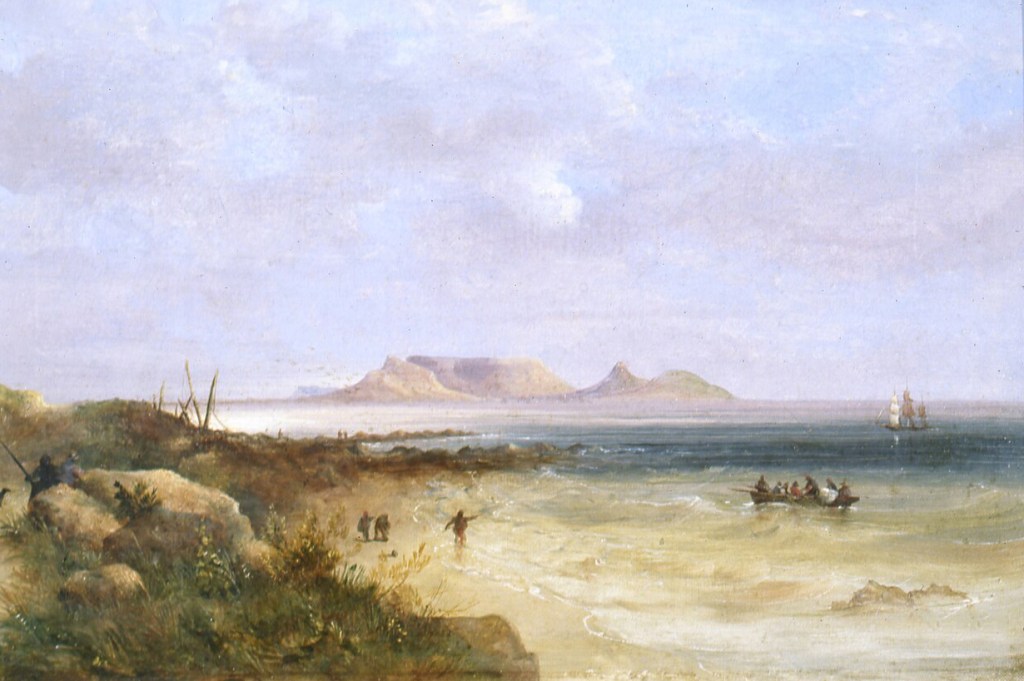
Fig. 4: ‘Table Bay’ (Thomas Bowler, 1900)
[1] Nationaal Archief. 1.04.02 Inventaris van het archief van de Verenigde Oost-Indische Compagnie (VOC), 1602-1795 (1811). Inventory number 12574, Middelwoud: Grootboek 1713–1714. Images 52–53. https://www.nationaalarchief.nl/onderzoeken/archief/1.04.02/invnr/@12754/file/NL-HaNA_1.04.02_12754_0052 [accessed 13 May 2026].
[2] Ibid. Images 54–61. https://www.nationaalarchief.nl/onderzoeken/archief/1.04.02/invnr/@12754/file/NL-HaNA_1.04.02_12754_0054 [accessed 13 May 2026].
[3] Huygens Institute. The Dutch East India Company’s shipping between the Netherlands and Asia 1595–1795. Details of voyage 2200.1 from Wielingen to Batavia: Middelwoud. https://resources.huygens.knaw.nl/das/detailVoyage/93260 [accessed 13 May 2026].
[4] Worden, Nigel. 2007. “Strangers Ashore: Sailor Identity and Social Conflict in Mid-18th Century Cape Town”. Kronos, no. 33, November. pp. 72–83.
[5] Kantharia, Raunek. 2024. “Why the Bay of Biscay is Dangerous for Ships?” Marine Insight https://www.marineinsight.com/why-the-bay-of-biscay-is-dangerous-for-ships/ [accessed 13 June 2026].
[6] Solar, Peter M; De Zwart, Pim. 2017. “Why were Dutch East Indiamen so slow?” The International Journal of Maritime History, vol. 29, no. 4. pp. 738–751.
[7] Riley, James. 1981. “Mortality on Long-Distance Voyages in the Eighteenth Century”. The Journal of Economic History, vol. 41, no. 3, September. pp. 651–656.
[8] Haarhoff, Johannes. 2007. “Water and Beverages on DEIC Ships Between the Netherlands and the Cape: 1602–1795”. Historia, vol. 52, no. 1. pp. 127–152.
[9] Worden, Nigel. 2007. “Food, Drink and Scurvy on VOC Voyages”. Kronos: Southern African Histories, no. 33, pp. 72–83.
[10] Bruijn, J.R., Gaastra, F.S. & Schöffer, I. 1979–1987. Dutch‑Asiatic Shipping in the 17th and 18th Centuries. The Hague: Rijksgeschiedkundige Publicatiën.
[11] Parthesius, Robert. 2010. Dutch Ships in Tropical Waters: The Development of the Dutch East India Company (VOC) Shipping Network in Asia 1595-1660. Amsterdam: Amsterdam University Press.
[12] Nationaal Archief. 1.04.02 Inventaris van het archief van de Verenigde Oost-Indische Compagnie (VOC), 1602-1795 (1811). Inventory number 10733 1714. Diary at Castle of Good Hope, 29 January 1714. Image 25. https://www.nationaalarchief.nl/onderzoeken/archief/1.04.02/invnr/@10733/file/NL-HaNA_1.04.02_10733_0025 [accessed 13 May 2026].
[13] Huygens Institute. The Dutch East India Company’s shipping between the Netherlands and Asia 1595–1795. Details of voyage 2200.1 from Wielingen to Batavia: Middelwoud.
Bibliography
Bruijn, Jaap, R; Gaastra, Femme S; Schöffer, Ivo. 1987. Dutch‑Asiatic Shipping in the 17th and 18th Centuries. Third volume. The Hague: Rijksgeschiedkundige Publicatiën.
Bruijn, Jaap R. 2011. Commanders of Dutch East India Ships in the Eighteenth Century. Woodbridge: Boydell Press.
Degroot, Dagomar. 2018. The Frigid Golden Age: Climate Change, the Little Ice Age, and the Dutch Republic 1560–1720. London: Perlego.
Fagan, Brian. 2019. The Little Ice Age: How Climate Made History 1300–1850. New York: Basic Books (Hachette Book Group). Kindle Edition.
Parthesius, Robert. 2010. Dutch Ships in Tropical Waters: The Development of the Dutch East India Company (VOC) Shipping Network in Asia 1595-1660. Amsterdam: Amsterdam University Press.
Sleigh, Dan. 2022. Retoervloot: Kaapstad en die VOC in 1713. Cape Town: Joanathan Ball Publishers. Kindle Edition.
Van Gelder, Roelof. 1997. Het Oost-Indisch avontuur: Duitsers in dienst van de VOC (1600–1800). Amsterdam: SUN Publishers.
References
Blussé, Leonard. 2003. ‘Sailing along the Wagenspoor: On the Sea-Road with the Dutch East India Company’. The Low Countries, vol. 11. pp. 91–100. Via Digitale Bibliotheek voor de Nederlandse Letteren https://www.dbnl.org/tekst/_low001200301_01/_low001200301_01_0012.php [accessed 14 May 2026].
Haarhoff, Johannes. 2007. “Water and Beverages on DEIC Ships Between the Netherlands and the Cape: 1602–1795”. Historia, vol. 52, no. 1.
Huygens Instituut. The Dutch East India Company’s shipping between the Netherlands and Asia 1595-1795. Details of voyage 2200.1 from Wielingen to Batavia: Middelwoud. https://resources.huygens.knaw.nl/das/detailVoyage/93260 [accessed 13 May 2026].
Kantharia, Raunek. 2024. “Why the Bay of Biscay is Dangerous for Ships?” Marine Insight https://www.marineinsight.com/why-the-bay-of-biscay-is-dangerous-for-ships/ [accessed 13 June 2026].
Petram, Lodewijk; Koolen, Marijn (ed); Wevers, Melvin (ed), van Koert, Rutger (ed); Van Lottum, Jelle (ed). 2024. ‘The Dutch East India Company’s Eighteenth-Century Workforce: an Enriched Data Collection’. Zenodo https://zenodo.org/records/10599528 [accessed 14 May 2026]. Includes downloadable dataset.
Riley, James C. 1981. “Mortality on Long-Distance Voyages in the Eighteenth Century”. The Journal of Economic History, vol. 41, no. 3, September.
Solar, Peter M; De Zwart, Pim. 2017. “Why were Dutch East Indiamen so slow?” The International Journal of Maritime History, vol. 29, no. 4.
Worden, Nigel. 2007. “Food, Drink and Scurvy on VOC Voyages”. Kronos, no. 33, November.
Worden, Nigel. 2007. “Strangers Ashore: Sailor Identity and Social Conflict in Mid-18th Century Cape Town”. Kronos, no. 3, November.
Image sources
Fig. 1: Van Keulen. Johannis. Ca 1700.‘Nieuwe Pascaert Beuattende in sich de Kust van Vlaenderen vande Wielingen tot de Hoofden’(New chart showing the coast of Flanders fromWielingen to Hoofden (the Heads)). Wikimedia Commons https://upload.wikimedia.org/wikipedia/commons/2/23/Johannes_van_Keulen_%281654-1715%29%2C_Nieuwe_Pascaert_Beuattende_in_sich_de_Kust_van_Vlaenderen_vande_Wielingen_tot_de_Hoofden_%28FL35073121_2536857%29.jpg [accessed 13 May 2026].
Fig. 2: Nationaal Archief. 2.10.01 Inventaris van het archief van het Ministerie van Koloniën, 1814-1849. Inventory number 3000 1711–1733. Image 43 https://www.nationaalarchief.nl/onderzoeken/archief/2.10.01/invnr/3000/file/NL-HaNA_2.10.01_3000_0043?t=schip%20middelwoud%201713&term=schip%20middelwoud%201713 [accessed 14 May 2026].
Fig. 3: Blussé, Leonard. 2003. ‘Sailing along the Wagenspoor: On the Sea-Road with the Dutch East India Company’. The Low Countries, vol. 11. Via Digitale Bibliotheek voor de Nederlandse Letteren https://www.dbnl.org/tekst/_low001200301_01/_low001200301_01_0012.php [accessed 14 May 2026].
Fig. 4: Bowler, Thomas. 1900. ‘Table Bay’. Held at the Iziko South African National Gallery, Cape Town. Wikimedia Commons https://commons.wikimedia.org/wiki/File:Thomas_Bowler_-_Table_Bay_-_Google_Art_Project.jpg [accessed 13 May 2026].


Leave a comment